
New Discovery of massive sulphide mineralization with zinc-lead-silver similar in type to the Sullivan Deposit
Location
The road accessible Dewdney Trail Property is located 30 km northeast of Cranbrook, British Columbia and covers more than 20,000 hectares (200 Km²) over a 15 km strike length of favourable geology with gold, copper, cobalt, zinc, lead and/or silver deposit potential.
History
In 1864, placer gold was discovered in Wildhorse Creek and started a gold rush to the Cranbrook area. Anecdotal information suggests at least 1.5 million ounces (46.7 million grams) of gold have been recovered from the creek; however, no corresponding lode gold deposits of any size have been discovered in the rock, suggesting the Wildhorse Creek Area has undeveloped potential for gold deposits. The Dewdney Trail Property is located upstream from placer deposits in Wildhorse Creek and may host the source of the placer gold.
Since 2010, PJX has consolidated 100% ownership of the mineral rights to claims comprising the Dewdney Trail Property.
In December 2010, RIT Minerals Corp. completed a 43-101 Technical Report (the “43-101”) on the Dewdney Trail Property for the PJX. A copy of the Technical Report was filed on SEDAR in 2011 and is available in the Company’s filings on SEDAR (www.sedar.com).
PJX has since compiled historical data and infilled data gaps with prospecting, mapping, geochem soil, silt and rock sampling, geophysics, and targeted trenching and drilling to help identify the most promising areas to host potential gold and base metal (copper, cobalt, zinc, lead) deposits.
In 2021, PJX optioned the right to acquire a 100% interest in the historical Estella Mine from Imperial Metals over a 5-year period. The Estella Mine closed in the 1960s. The mine produced zinc, lead and silver in concentrate from a vein. The small Estella Mine Property (2.24 km²) is located within the outer boundary of PJX’s large Dewdney Trail Property.

Exploration Potential
Exploration has identified 3 target areas with the potential to host significant mineral deposits.
• Estella Basin target area with potential for multiple deposit types – Newly discovered Sullivan type sediment hosted (zinc, lead, silver) mineralization, and intrusion related gold-copper-silver-molybdenum mineralization.
• Lewis Ridge target area - Sullivan type sediment hosted (zinc, lead, silver), and/or Black Butte or Mt. Isa sediment hosted copper-cobalt deposit potential.
• Tackle Basin target area - Orogenic and/or intrusion related gold deposit potential.
Property map shows PJX’s target areas in the Sullivan Mining Camp and Vulcan Gold Belt, including Estella Basin, Lewis Ridge and Tackle Basin.
Dewdney Trail target areas all occur within the hinge and/or limb of a large regional north-south oriented overturned anticline fold structure.
Mineralization also occurs in sediments similar in age (Proterozoic) and/or type (turbidites, quartzites) to other deposits such as Telfer, and Sukhoi-log.
Sediments have been intruded by felsic intrusives (syenite/alkalic porphyries) possibly similar in age (Cretaceous to possibly Eocene) to deposits such as Fort Knox in Alaska or the Butte mining district in Montana.
PJX contracted Expert Geophysics to fly an 895 km airborne survey with a tight flight-line spacing of 100m to be able to identify and define shallow and deep targets across the entire Dewdney Trail Property. The survey has helped identify numerous potential intrusive related and sediment hosted type deposit targets to test.
Estella Basin, Lewis Ridge and Tackle Basin Target Areas
The unique geology of the Dewdney Trail Property has 2 separate mineralizing events defined by age and type of potential deposit. The 2 events appear to overlap one another, with the first being older Proterozoic age Sedimentary Exhalative (Sedex) hosted zinc, lead, silver mineralization, and the second being a younger Cretaceous to possibly Eocene intrusion related gold, copper, silver, and possible molybdenum mineralizing event.
Estella Basin – Lewis Ridge Target Areas (approximately 4 km x 2 km)
Proterozoic Age Sediment Hosted (Sedex) Zinc-Lead-Silver and Other Critical Metals
New Discovery: In late 2023, prospecting discovered sediment-hosted massive to semi-massive sulphide mineralization similar in style and grade to the Sullivan Deposit. Mineralization includes zinc, lead, silver, copper, cadmium, cobalt, and the potential for other critical metals including indium.
Drilling in 2024 identified a vent environment in the historical Estella mine area and 4 sedimentary horizons (A, B, C, and D) with potential to host a deposit. Drilling and prospecting in 2025 have outlined a large mineralizing system associated with the C horizon that is capable of hosting multiple deposits, similar to the mineralizing system in the Sullivan Basin that hosts the Sullivan and Northstar deposits. The potential spans from 800 m south of the historical Estella Mine target area to over 2,000 m north to the Lewis Ridge target area.
Geology map below displays 2 target areas (historical Estella Mine and Lewis Ridge) with venting environments that have the potential to host Sedex mineral deposits.
Historical Estella Mine Area Venting Environment
- 2025 drilling intersected a very thick Quake zone (estimated at about 30 m true width) with pervasive strongly anomalous zinc-lead-silver mineralization throughout the zone.
- Tourmalinite, an alteration associated with venting at the Sullivan deposit, occurs within and above the Quake zone.
- Bedded sulphide Sedex mineralization occurs in bands above and below the Quake zone.
- Sullivan style and grade massive to semi-massive sulphide boulders discovered in late 2023 occur downslope of the drilling.
- Sedex semi-massive to massive zinc-lead-silver boulders are also found 800 m to the south along strike of the Quake zone.
Lewis Ridge Target Area Venting Environment
- Stacked bands of tourmaline-altered sediments occur 2 km north and on strike with the thick Quake zone intersected by drilling.
- Large coincident zinc, lead, silver, copper, gold soil anomalies occur stratigraphically above the tourmaline-altered zone.
- This area has not yet been drilled.
The Sullivan basin mineralizing system produced 2 deposits — the Sullivan and Northstar — that are about 2 to 3 km apart. This is similar to the 2 km spacing between the Estella area venting environment and the Lewis Ridge venting environment.
The Kootenay King Sedex zinc-lead-silver deposit is 6.5 km on strike to the south and on strike with the Quake zone.
PJX plans to focus exploration and future drilling on these target areas to potentially discover a Sullivan type Sedex deposit.
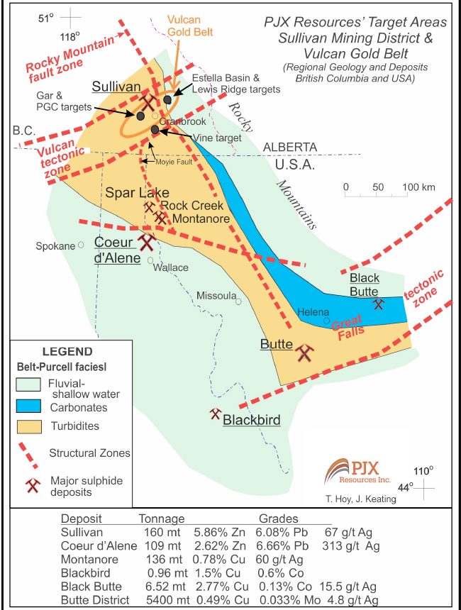
The world class Sullivan Sedex deposit is located 25 km west of the Dewdney Trail Property. The 160 million tonne deposit produced ore containing some 17 million tonnes of zinc and lead metal and more than 285 million ounces of silver during 90 years of operation before closing in 2001. (Source: The Teck-Cominco Sullivan Mine Legacy in Kimberly, British Columbia, Nov 5, 2001, news release)
Cretaceous to Possible Eocene Age Intrusion Related Gold-Copper-Silver (Possible Molybdenum)
Possible magmatic centers with multiple phases of porphyritic syenitic/alkalic intrusions are believed to be Cretaceous to possibly Eocene in age.
Gold, silver, and copper mineralization occur in multi-phased, variably altered, and veined syenitic/alkalic porphyritic intrusive dykes.
Photo A: Intrusive phase containing disseminated pyrite and chalcopyrite in the groundmass. A separate grab sample (MS22-57) of this intrusive phase with quartz veining analyzed:
- 6.9 g/t gold
- 447 g/t silver
- 1.108% copper
(See Estella Basin map with gold analyses of intrusions and table of gold in rock grab samples.)
The intrusion/dyke has been cross-cut and locally altered by quartz-carbonate veins with gold, copper, and silver.
Tackle Basin Target Area (approximately 2 km x 2 km)
Orogenic and/or Intrusive Related Gold Deposit Potential
Gold is the dominant element in soils in the Tackle Basin area. (See geology maps with various soil analyses.)
Tackle Basin is in the headwaters of the Wildhorse placer gold creek. It is a large basin with placer gold in the creeks draining the basin.
One favourable gold-bearing quartzite-argillite unit ranges from 75 to over 200 m true width. Gold occurs with quartz veins or quartz stockwork zones and silica, sericite and carbonate alteration in the sedimentary unit.
Summary and Next Steps
Large deposits like the Sullivan often occur in large mineralizing systems. The large system identified by drilling and exploration in 2025 is associated with high grade critical metal mineralization as evidenced by the Sullivan Style and grade of boulders found in talus at the bottom of the mountain slope. We now know that it is not only a large system in width, but also has strike potential, as indicated by the discovery of mineralised boulders 800 m to the south and the bands of tourmalinite and large multi-element geochemical soil anomaly 2,000 m to the north.
The Dewdney Trail Property exploration permit from the Government of British Columbia is good until July 2029.
Next steps will include additional compilation of drill results with geophysics and geological data from mapping to refine targets for the next phase of drilling with the use of helicopters and/or ground support. For example, one target to test is the area with newly discovered Sedex mineralized boulders 800 m south and on strike with the large Quake zone. The existing drill trail has been extended to this area with plans to drill when the snow melts, possibly in May or early June 2026.

Geology Map – Sullivan Mine and PJX’s Dewdney Trail Target Areas (Estella Basin, Lewis Ridge, Tackle)
Dewdney Trail targets occur in a similar geological environment to the Sullivan Deposit.- ● Jackleg fault is believed to be the eastern extension of the Kimberley fault that influenced the formation of the Sullivan deposit.
- ● 2025 drilling and prospecting have identified a large Sedex mineralizing system at Dewdney Trail similar ot Sullivan mineralizing system. (tourmalinite, fragmentals, quake zones, venting, bands of disseminated to massive sulphide mineralization)
- ● Historical Sullivan Mine and Northstar Mine were approximately 2 to 3 km apart, similar distance between the Estella and Lewis target areas at Dewdney Trail.
 Sullivan style and grade Sedex massive sulphide boulders discovered with syenite intrusive boulders in talus at the bottom of a mountain slope. This boulder is angluar and large and not considered to have travelled far. Drilling upslope from the boulders in 2025 intersected a large Quake zone, bands of Sedex mineralization, and tourmalinite indicative of a large mineralizing system. Syenite dykes dip subparallel to the mountain slope and mask the geology and deposit potential beneath them.
Sample STM-23-1 (6.71% zinc, 2.23% lead, 16.05 g/t silver, 1258.9 ppm or 0.12% copper)
Boulder in talus, similar in style and grade to Sullivan Sedex mineralisation. Sphalerite (zinc sulphide), galena (lead sulphide), and iron sulphides (pyrite, pyrrhotite) occur banded or bedded in apearance as seen above. Mineralization also occurs in the groundmass of the rock. Disruption from venting and shaking of the ocean floor, after the mineralization was deposited, may have caused the beds to be broken and fragmented. Quake zones represent periods of disruption from venting and shaking of the ocean floor.
Sample STM-23-7 (9.33% zinc, 2.48% lead, 14.62 g/t silver, 495 ppm or 0.04% copper)
Sullivan style and grade boulder in talus at the bottom of the mountain slope below the 2025 drilling. Alternating dark and light coloured beds with sulphides (zinc, lead, iron) are sulphide-rich beds that have broken apart by basin disruption as evidenced by the Quake zone. The source band of this bedded sulpide mineralization may be at depth stratigraphically below the zinc rich Quake zone intersected in hole ND25-26 and above a lower Quake zone encountered by drilling near the historcal Estella Mine.
Sample STM-23-8 (3.55% zinc, 0.98% lead, 7.5 g/t silver, 442.1 ppm or 0.04% copper)
Boulder in talus. Although this sample is lower in grade it tells an important story. The individual massive sphalerite fragments are a possible indicator of higher grade zinc rich massive sulphides in bedrock possibly buried under the talus slope.
 Sedex massive sulphide boulder from talus at bottom of mountain slope. Syenite dykes intrude along bedding and crosscut beds along axial planar clevage.
 In late 2023, PJX’s prospecting team discovered Sullivan Sedex style and grade boulders with sulphide mineralization in an area about 50 metres (m) by 150 m at the base of a talus slope. Ten samples have been analyzed with grades shown in the table above. Boulders are down slope from the 2025 drilling that intersected a large mineralizing system with a thick mineralized Quake zone, bands of Sedex sulphide mineralization, and tourmalinite (alteration associated with venting at the Sullivan deposit). Younger syenite dykes have intruded into the sulphide zone. More drilling is required to test for the source of the boulders below the dykes and on strike.
 2025 drilling discovered large Quake zone that represents a period of disturbance in the ocean floor when faults and vents are active and carried metals in fluids to form mineral deposits beneath and on the ocean floor. Zinc, lead, silver, and other metals are very anomalous and pervasive throughout 63.7 m of Quake zone (see Quake Zone analyses table). Photo is an example of part of the Quake zone - NQ core from 176.70 m to 184.67 m in hole ND25-26, disrupted sediments and fragmentals occur throughout the zone. Sericite and chlorite alteration are dominant with local tourmalinite. Sphalerite (zinc sulphide), galena (lead sulphide) are disseminated to fracture and locally vein controlled. Blebs of pyrrhotite/pyrite (iron sulphides) also occur in the Quake zone.
 Drilling in 2025 discovered bands of bedded disseminated to semi-massive and massive sulphide Sedex mineralization in hole ND25-25 (73.5-74.5 m) with 1.13% zinc from 73.77-74.22 m, and in ND25-26 from 73.7-74.0 m that assayed 1.65% zinc. The 2 bands are separate zones and represent stacked layers of bedded mineralization. Bands are similar in thickness to the thickness range of some bands at the Sullivan (see Diagram 1). Although the bands are low in grade, Sullivan-grade boulders discovered in talus at the bottom of the slope support the presence of higher-grade bands that have not yet been intersected.
 Table of Quake Zone Analyses - 63.7 m intersection in hole ND25-26 (172.3 m – 236.0 m) Strongly anomalous zinc, lead, silver, and other metal values are pervasive throughout the Quake zone. True thickness of the zone is estimated at about 30 m. The considerable thickness and consistent mineral content of the zone is indicative of a large mineralizing system and supports the potential to produce a significant deposit. The zone represents a period of disturbance in the ocean floor when faults and vents are active and carried metals in fluids to form mineral deposits beneath and on the ocean floor.
 Analyses were by ICP-MS performed in accordance with MSALABS Inc.’s analytical methods in Langley, British Columbia.
Sample SKX25-11 (4.89% zinc, 32.23% lead, 546 g/t silver)
2025 disovery of banded massive sulphide boulder 800 m south on srike with the 2025 drilling. Grey mineral is galena (lead sulphide), black band is magnetite.
Sample SKX25-14
2025 discovery of banded massive sulphide boulder found 800m south on strike with 2025 drilling. Reddish-brown coloured bands and beds of sphalerite (zinc sulphide) in sediments. Black band is magnetite.
Geology and Zinc in Soil Map with 2 venting environments that could produce mineral deposits.
1) Historical Estella Mine Area venting environment - New drill intersected thick Quake zone with pervasive zinc-lead-silver mineralization, tourmalinite, stacked bedded sulphide Sedex mineralization, and Sullivan style and grade massive to semi-massive sulphide boulders downslope from drilling. Sedex semi-massive to massive zinc-lead-silver boulders are also found 800m to the south along strike of the Quake zone.
2)Lewis Ridge Target Area venting environment – stacked bands of tourmaline altered sediments 2 km north and on strike with the thick Quake zone intersected by drilling. Large coincident zinc, lead, silver, copper, gold soil anomalies occur stratigraphically above the tourmaline altered zone. This area has not yet been drilled.
Sullivan basin mineralizing system produced 2 deposits, the Sullivan and Northstar that are about 2 to 3 km apart. This is similar to the 2 km spacing between the Estella area and Lewis Ridge venting environments.

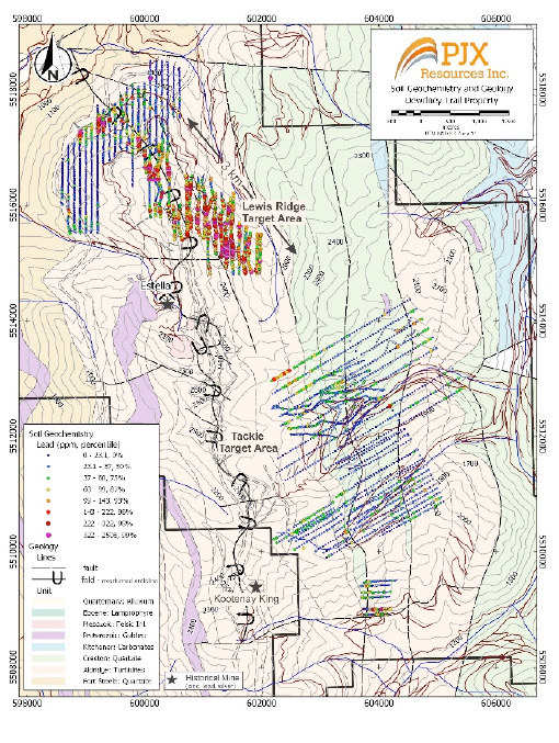
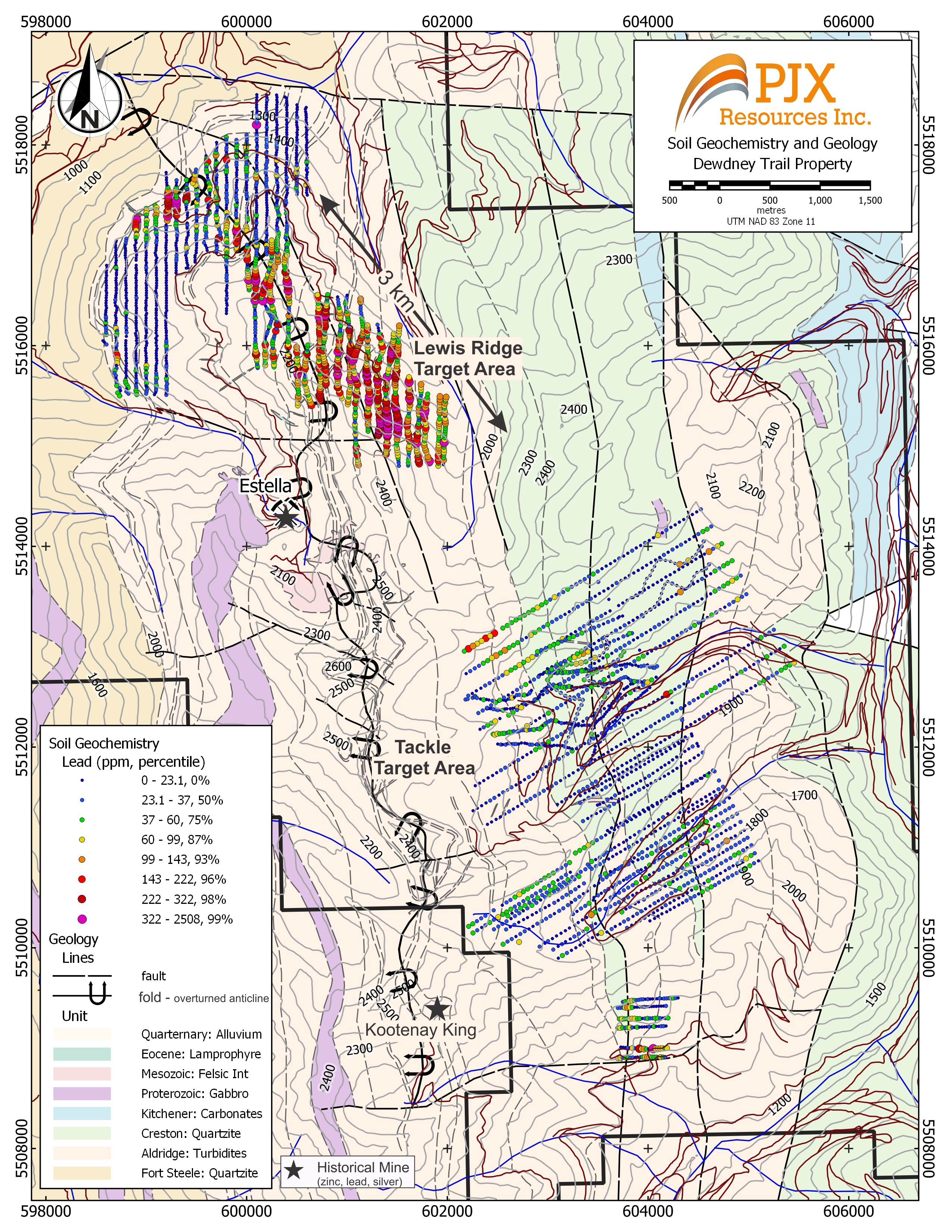
Geology and Lead in Soil Map with Historical Estella Mine and Lewis Ridge venting environments.

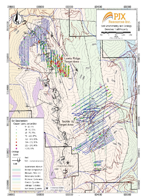
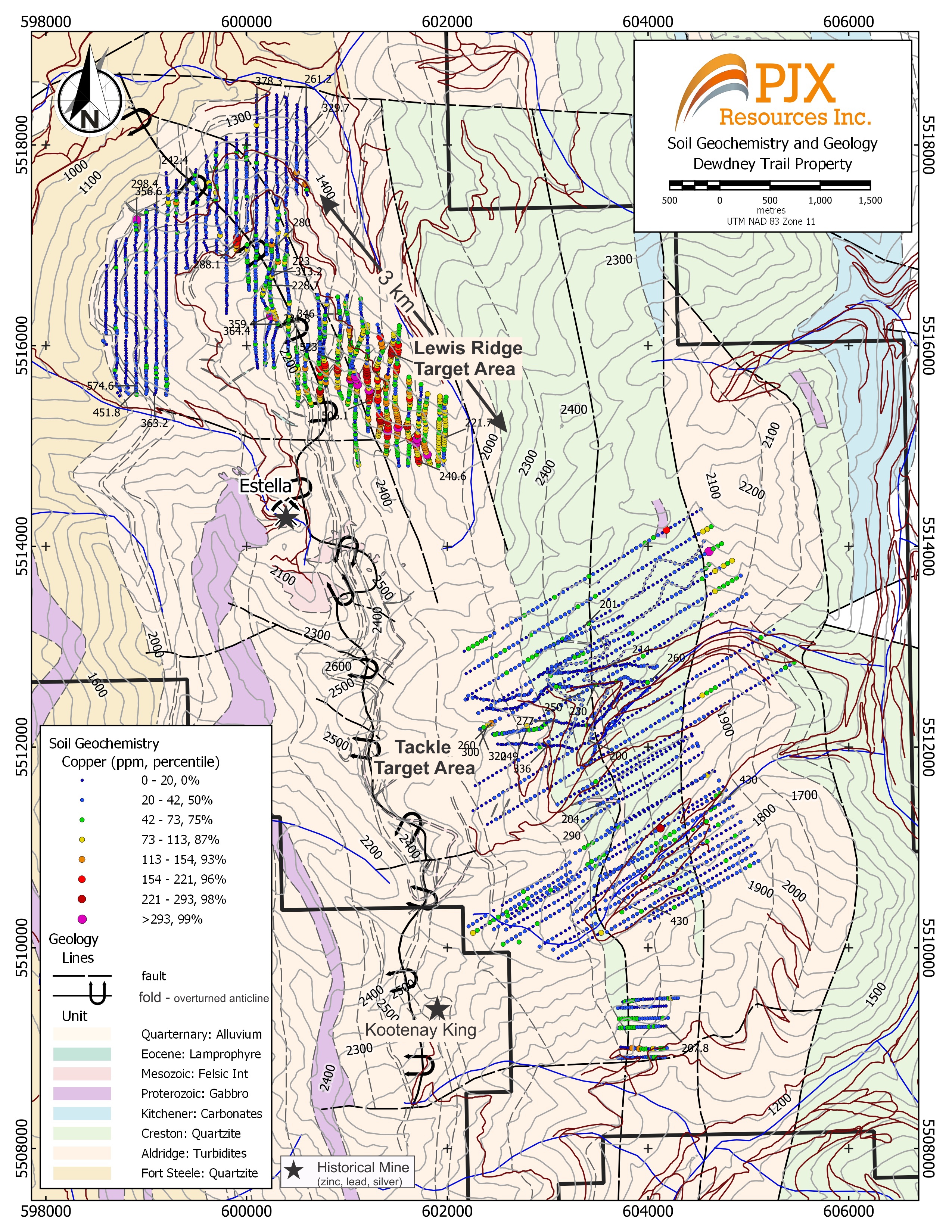
Geology and Copper in Soil Map with Historical Estella Mine and Lewis Ridge venting environments.

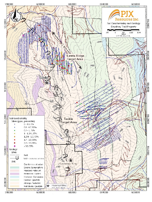
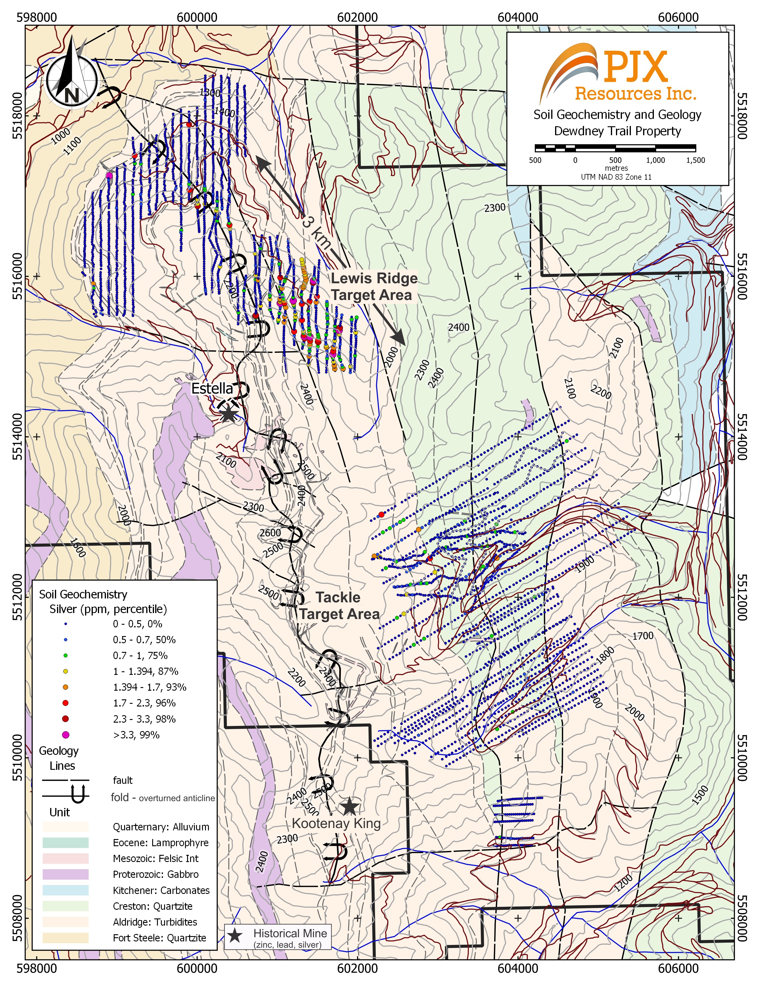
Geology and Silver in Soil Map with Historical Estella Mine and Lewis Ridge venting environments.

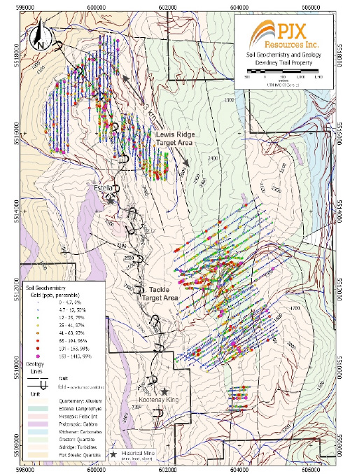
Geology and Gold in Soil Map with Historical Estella Mine and Lewis Ridge venting environments.

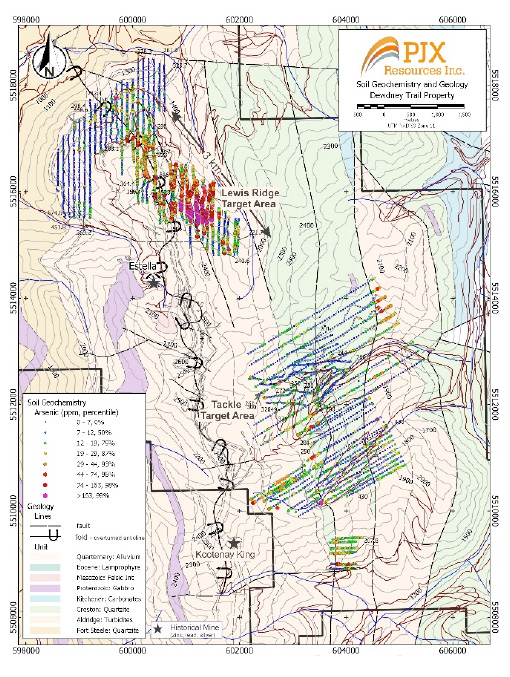
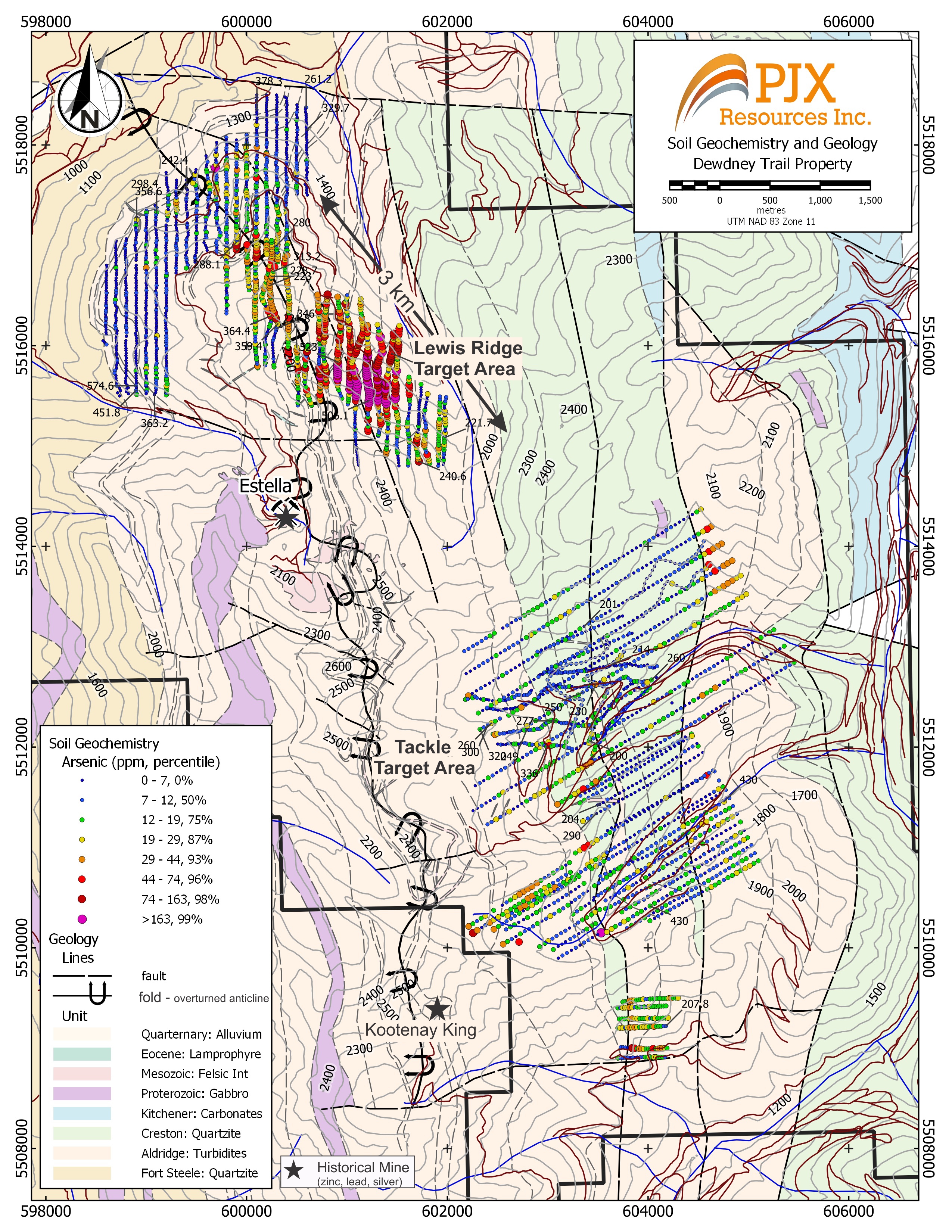
Geology and Arsenic in Soil Map with Historical Estella Mine and Lewis Ridge venting environments.

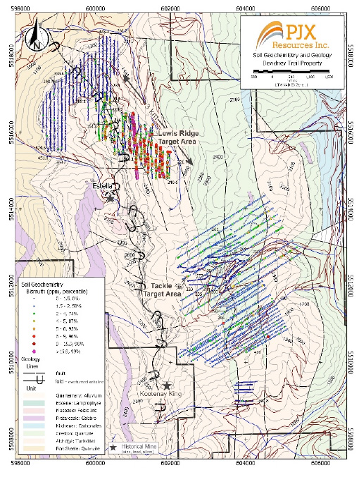
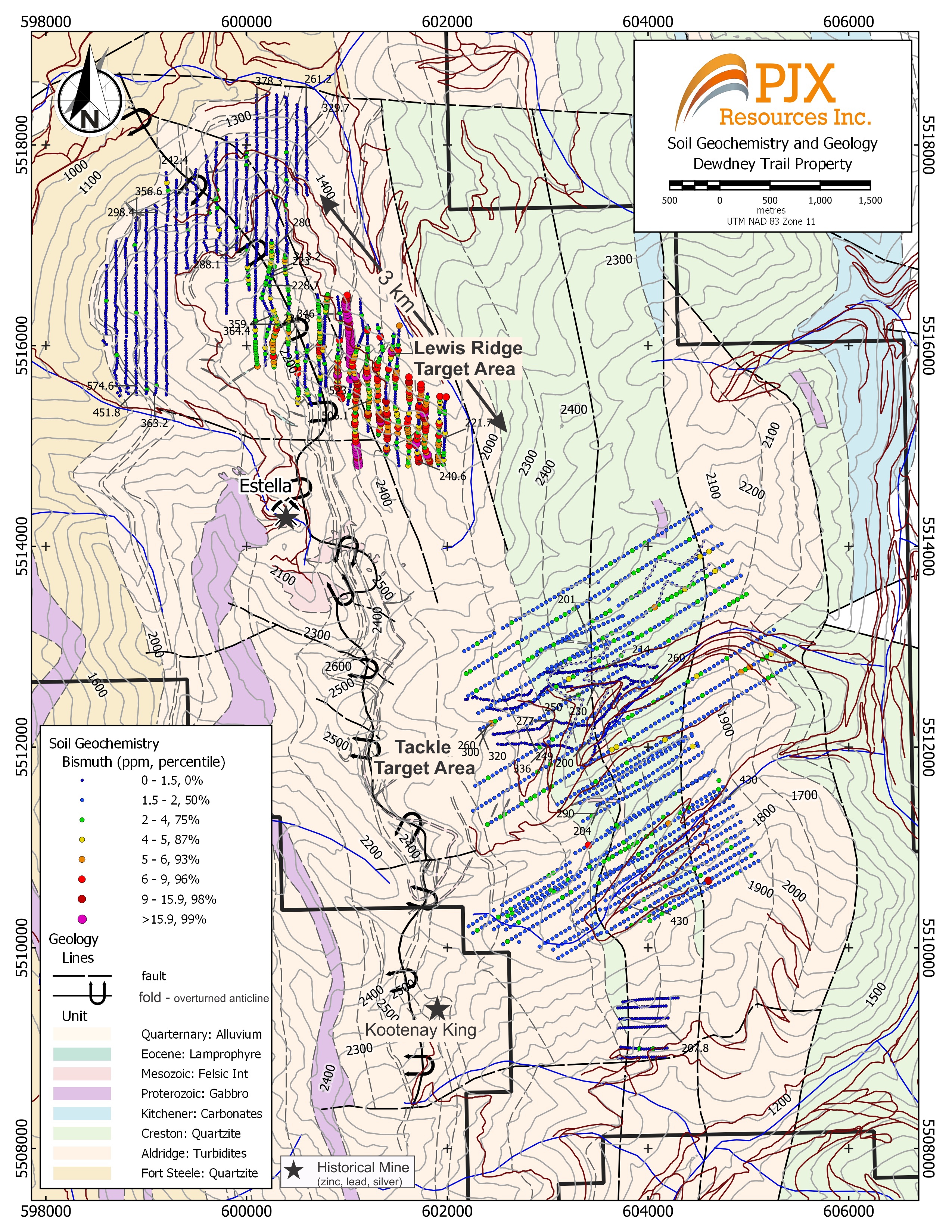
Geology and Bismuth in Soil Map with Historical Estella Mine and Lewis Ridge venting environments.

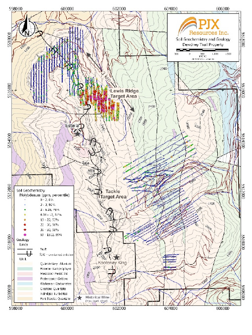
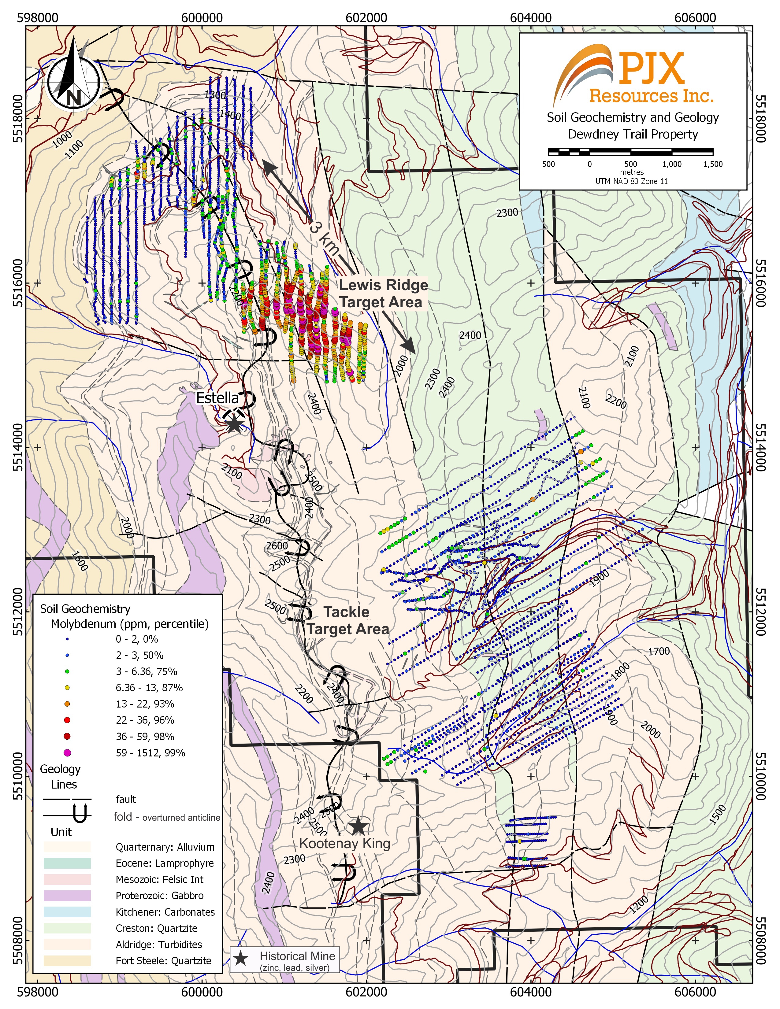
Geology and Molybdenum in Soil Map with Historical Estella Mine and Lewis Ridge venting environments.
 Gold analyses of rock grab samples of quartz veins in alkalic (syenite) intrusions. Mapping and drilling indicate the “Cliff” intrusion is a dyke subparallel to the slope of the mountain topography and follows axial plane cleavage.
 Estella Basin - Rock grab sample analyses of syenite intrusions/dykes with quartz veins. Sample locations are shown on Estella Basin rock geochemistry map.
Photo A – Rock grab sample of intrusive phase similar to MS22-57.
Vancouver Petrographic’s assessment indicates that pyrite (iron sulphide), chalcopyrite (copper sulphide) blebs and hematite (iron oxide) are scattered in the groundmass. The rock is a micro-fractured porphyritic quartz-bearing syenite dominated by fine to very coarse, subhedral to euhedral K-feldspar phenocrysts (in places, replaced by calcite), intergrown with accessory plagioclase phenocrysts and quartz, floating within a groundmass that is dominated by K-feldspar, intergrown with plagioclase, quartz, muscovite flakes, plus minor apatite and scattered calcite spar. Discontinuous veinlets, crosscutting phenocrysts and groundmass are filled with calcite and quartz. A separate rock grab sample (numbered MS22-57) of this phase of porphyry with quartz veins analyzed 6.9 g/t gold, 447 g/t silver, 1.1% copper.
Regional Geology Map with Sullivan and Butte Mining Districts.
Sullivan and Butte Mining Districts both occur where continental scale structures intersect. The Rocky Mountain Trench Fault intersects the Vulcan tectonic zone in the Sullivan District and the Great Falls tectonic zone in the Butte District. These large intersecting structures penetrate deep in the Earth’s crust. The intersections provide pathways for intrusions and fluids to follow and create sediment-hosted deposits like the Sullivan and intrusion related deposits in Butte.
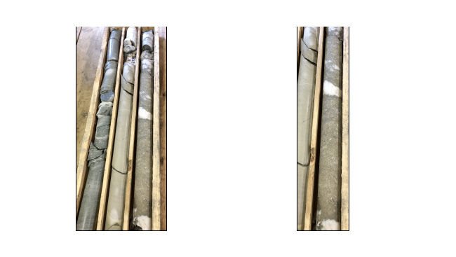
Lewis Ridge Target – drill hole LR22-02 Massive sulphide (pyrite) with anomalous cobalt, copper, nickel and silver mineralization in a quartz-dolomite gangue (white mineralization). On the right is an enlarged photo of the massive sulphide to display the fine to coarse pyrite texture.
• 1.42 m wide (drill width) zone with 60% massive sulphide intersected from 125.87m to 127.29 m down hole, analyzed 644 ppm (0.06%) Cobalt, 819 ppm (0.08%) Copper, 144 ppm Nickel and 2.66 ppm (2.6 g/t) silver.
• Possible sediment hosted mineralization similar to the Black Butte copper-cobalt deposit that also occurs with anomalous nickel and silver in quartz-dolomite gangue.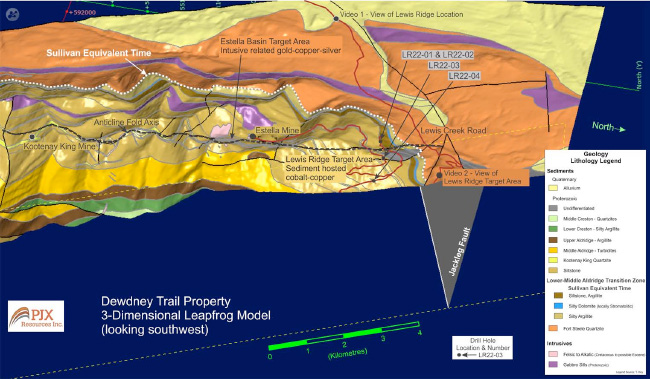
Dewdney Trail Geology map draped on topography. Lewis Ridge (cobalt-copper) and Estella Basin (gold-copper-silver) target areas occur along the same anticline fold axis as the historical Estella and Kootenay King Mines. The Lewis Ridge target occurs at or near a geological horizon that is equivalent in depositional time to the Sullivan Deposit located about 25 km to the west. The Jackleg Fault may be the eastern extension of the Kimberley Fault that influenced the formation of the Sullivan deposit.
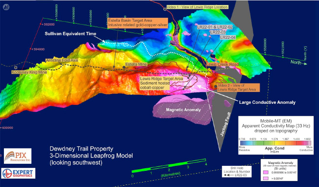
Apparent Conductivity Map draped on topography. Conductive Anomaly defines a large area, over 2.5 km long and 1.5 km wide. Massive sulphide (pyrite with anomalous cobalt and copper) and locally graphitic/calcareous sediments intersected in hole LR22-02 are conductive. The large Magnetic anomaly at depth may represent an area with greater sulphide content containing copper and cobalt that has been folded along the east limb of the wide overturned anticline fold.
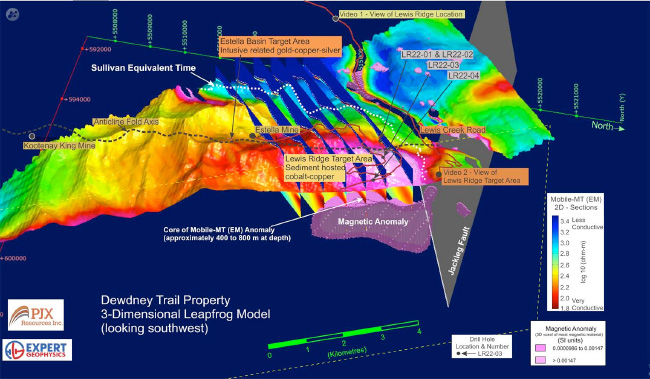
2-Dimensional modelling of six of the 30 flight lines over the Lewis Ridge Target display a potentially more conductive area at depth (400 to 800m) that appears to correlate with the magnetic anomaly defined by 3 Dimensional modelling. Conductive and magnetic anomalies support the potential for sulphide mineralization. Sulphide zone intersected in LR22-02 and the magnetic anomaly at depth will be a focus of future drilling.
Belt-Purcell basin geology map. Lewis Ridge target and Black Butte deposit both occur on the east side of the basin and were formed in shallower water environments and in similar age rock.
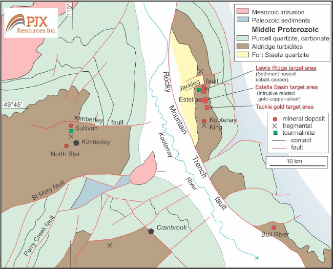
Sullivan Mining District geology map with Dewdney Trail Property target areas. The Kimberley Fault influenced formation of the Sullivan Deposit. The Jackleg Fault may be the eastern extension of Kimberley fault.
Gold in Soil Samples
Copper in Soil Samples
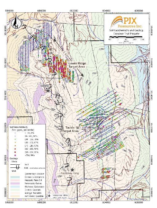
Zinc in Soil Samples
Lead in Soil Samples
Bismuth in Soil Samples
Molybdenum in Soil Samples
Arsenic in Soil Samples
Silver in Soil Samples


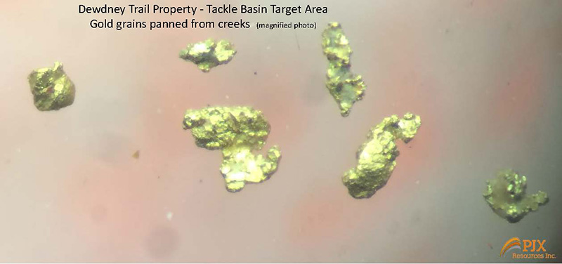
Placer Gold Tackle Basin Area
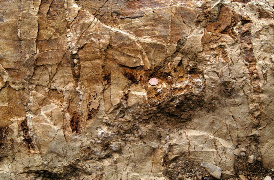
Typical vein morphology and spacing within quartzite. Bedding is horizontal in photograph, most veins are perpendicular to bedding. Note the close spacing (Cdn penny for scale) of veins, and vein widths from millimeter to centimetre scales.
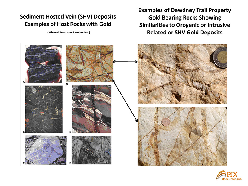
Gold Bearing Rock Comparison
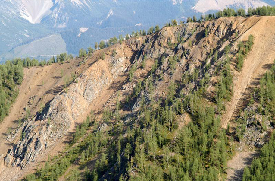
View southeast at quartzite forming the headwall of Lewis Creek. Intense sericite-quartz-pyrite-Fe-carbonate alteration imparts orange weathering color. Rock and soil samples are anomalous in gold.

Anticline Fold Dewdney Trail
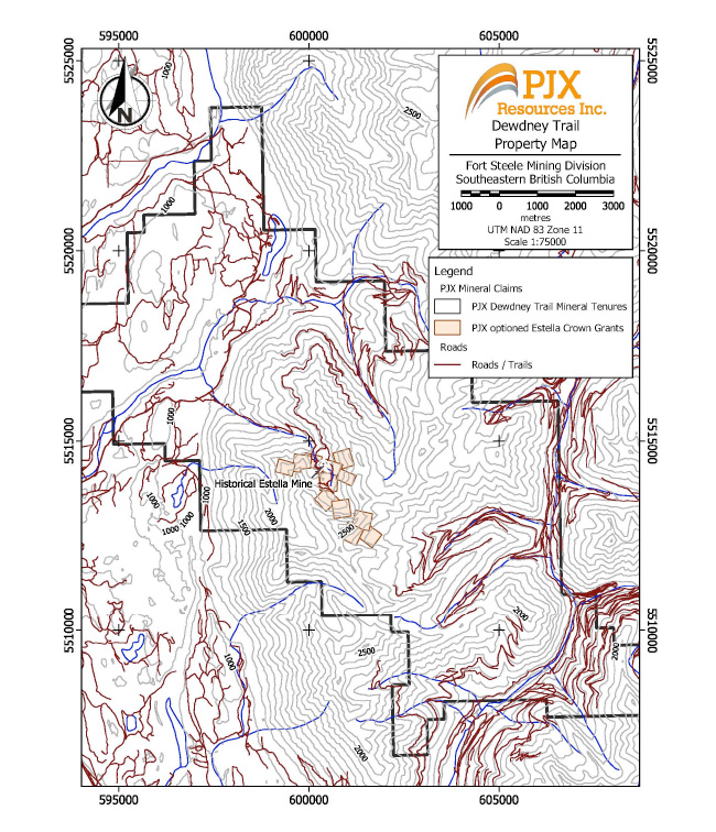
Dewdney Trail Property map with Estella Crown Grants and road/trail access