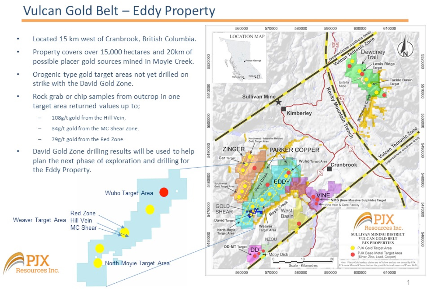
Location
The road accessible Eddy Property is located 14 kilometres southwest of Cranbrook, British Columbia.
History
The Eddy Property is located within the Vulcan Gold Belt of the Sullivan Mining District. The 28 km long and over 15,000 hectare size property extends along the north flank of a placer producing creek called Moyie Creek. Placer mining for gold in the Moyie Creek drainage first began in the late 1860’s with localized placer mining still going on today. PJX is focused on discovering the bedrock source of the gold and other metals that has been washed out of the rock and into the Creeks.
Exploration Potential
The Eddy Property has potential to host multiple types of deposits including intrusive related copper-gold-cobalt and orogenic gold deposits. PJX has compiled historical data and infilled data gaps with new mapping, geochem sampling, geophysics, computer modelling and drilling to identify gold, copper, lead, zinc, silver and/or cobalt targets along the entire property.
The Eddy Property is adjacent to and on strike with the high-grade David Gold Zone on PJX’s Gold Shear Property. An important part of our gold strategy is to explore the David zone to increase its’ size and also increase our understanding of structural and other controls that influence the location of high-grade gold mineralization. This knowledge is helping to explore and define gold targets on the Eddy and other properties.
The Eddy Property has been divided into 3 target areas; Wuho Creek , Weaver Creek, North Moyie Creek (see map below). The division is based on regional structures, kinematics, local geology, and the type of multiple mineral occurrences in each area. Each area has potential to host multiple deposits. PJX is exploring all 3 areas. The Wuho target potential is presented below. The Weaver and North Moyie target potential will be presented in the future as results are received and data compiled.
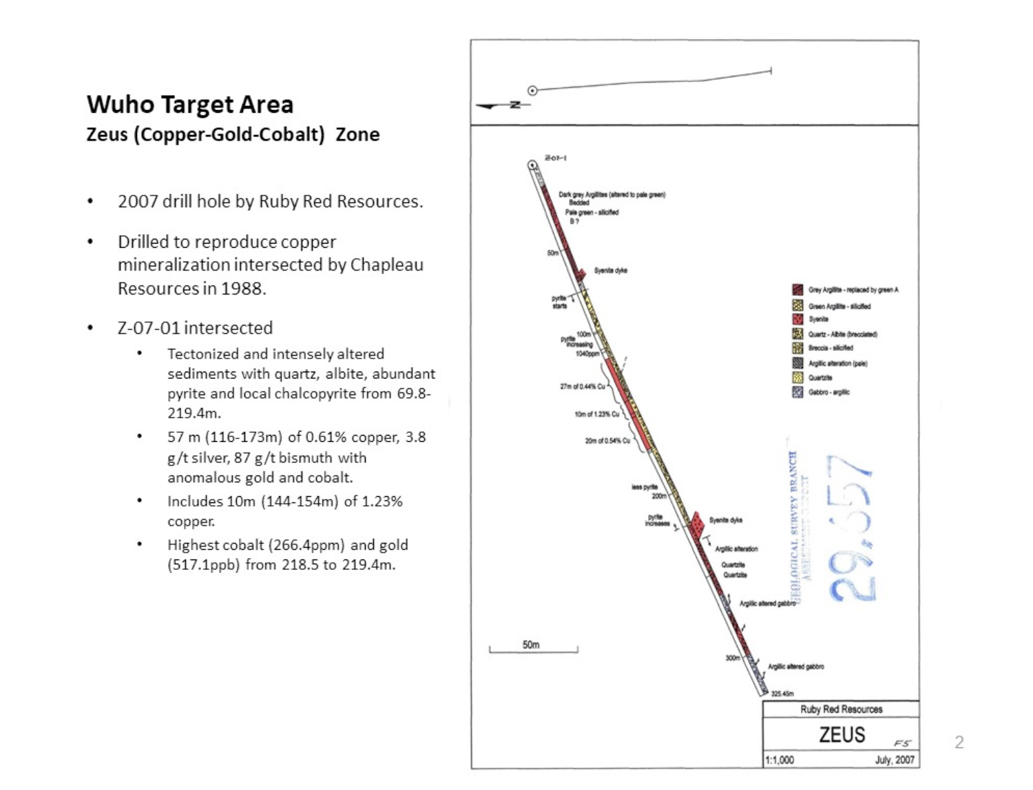
The Wuho Creek target area is north of the Weaver Creek target area on the Eddy Property. Wuho has potential to host intrusive related copper, gold, silver, bismuth, and/or cobalt type deposits, as well as orogenic type gold deposits, and possibly sediment hosted copper cobalt type deposits.
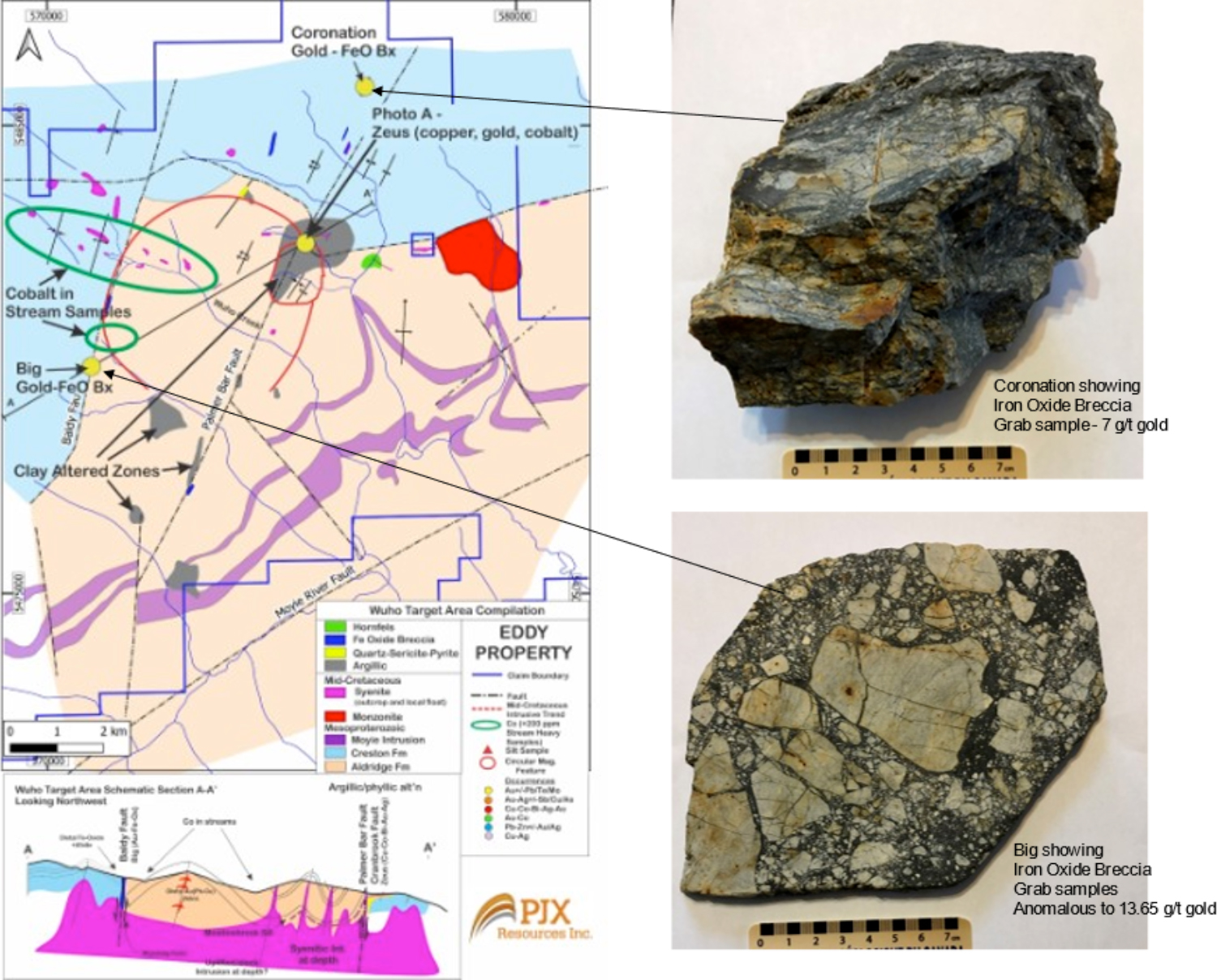
For example, copper, silver, cobalt and gold mineralization in a 2007 drill hole in conjunction with iron-oxide breccia outcrops with gold mineralization, cobalt in stream sediments, and large clay altered areas at surface support the potential to discover a possible IOCG (Iron-Oxide-Copper-Gold) type deposit at depth. The Olympic Dam mine, in Australia, is an example of an IOCG type deposit.
Wuho Target Area Highlights
- Historical hole (Z-07-01*) drilled in 2007 by previous explorers on the Zeus zone in the Wuho target area intersected 10m of 1.23% copper within a broader 57m (116-173m) interval of 0.60% Copper, 3.8 g/t silver, 87 g/t bismuth, 36 ppb gold, 64 ppb cobalt. (see photo A below).
- Copper, silver, cobalt and gold mineralization occur within tectonized and intensely altered sediments with quartz, albite, abundant pyrite, and local chalcopyrite from 69.8-219.4m in hole Z-07-01.
- Highest gold (517.1ppb) and cobalt (266.4ppm) as an individual analysis was from 218.5 to 219.4m.
- One large primary ring feature (approximately 4 km diameter) appears to be disrupted by a secondary ring feature (approximately 1.5 km diameter).
- Rock grab sample of the Coronation iron-oxide breccia taken by prospectors working with PJX analyzed 7 g/t gold.
- Five of ten historical rock grab samples by prospectors of the Big iron-oxide breccia returned values ranging from 40 to 633 ppb gold with a sixth sample analyzing 13,650 ppb (13.65 g/t) gold.
- Historical heavy stream samples with over 200ppm cobalt occur in Wuho Creek.
- Gold and iron-oxide occurrences are found along major structures (Palmer Bar and Baldy faults) on the margins of the ring features.
- These structures provide additional pathways for gold, copper, silver, and cobalt mineralizing fluids.
- Large clay altered zones suggest areas where fluids have passed through the rocks from a possible mineralizing system at depth.
- Zeus zone occurs along the intersection of the possible primary and secondary ring structures.
- VTEM airborne magnetic survey flown for PJX has identified ring shaped features that may represent ring structures formed by collapsed intrusives at depth.
- Large mineralizing systems that form large deposits can occur where multiple phases of intrusives have collapsed at depth and release fluids and gas that transport gold, copper and other elements which can become trapped in the top of the intrusive or proximal country rocks to form deposits.
*Cautionary Note: The source of data for historical drill hole: BC Geological Survey Branch Assessment Report 29657. PJX Resources Inc. has not verified the data presented in the report.
Next Steps
PJX plans to continue exploring the North Moyie and Weaver target areas for orogenic type high-grade gold mineralization, and also determine if the Zeus zone in the Wuho target area has a preferred orientation (strike and dip) to help vector toward additional mineralization. Geophysics and soil sampling surveys are also planned to define additional drill targets in the large clay altered zones and possible ring structures on strike with the Zeus zone.
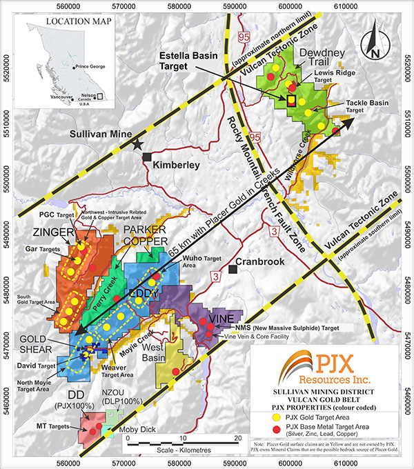
Regional Map of PJX Properties and Exploration Targets

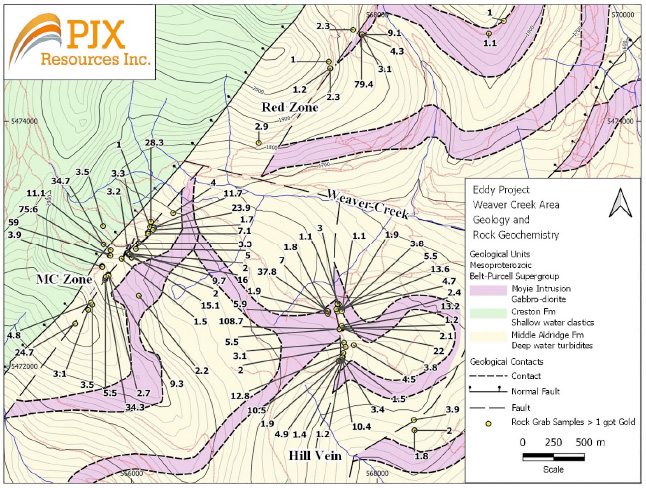
Weaver Target Area – Potential large gold mineralizing system defined by 3 large gold targets (MC Zone, Hill Vein, Red Zone) over a 4 km by 2.5 km area centered on the Weaver Creek cross structure.
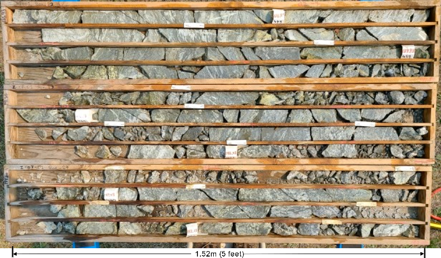 Historical drill hole Z-07-01 core from 135.93 to 153.04m. Ten metres from 144-154m averaged 1.23% copper.
 Geology map displays Zeus copper-silver-gold-cobalt zone with large clay alteration zone (gray area on map) at intersection of possible collapsed intrusives at depth. Iron-oxide breccias, locally containing gold, occur along 2 large regional structures (Baldy and Palmer-Bar faults). Heavy mineral stream samples contain >200ppm cobalt (areas outlined in green on map). Schematic cross-section A-A’ shows possible collapsed intrusive at depth, with syenite (purple) and monzonite (red) intrusives at surface.
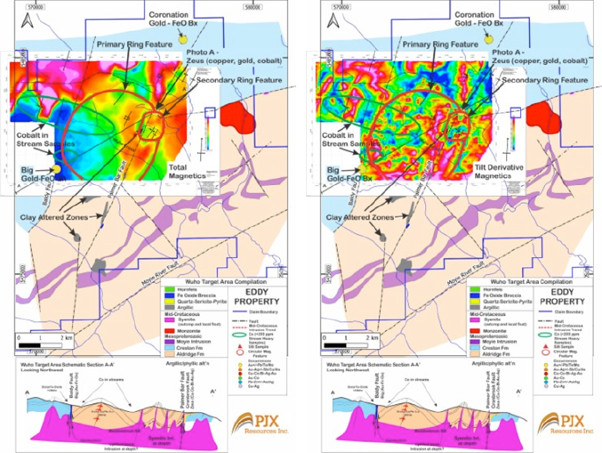 Airborne VTEM Total Magnetics on left, and Tilt Derivative Magnetics on right, overlain on geology map. Magnetic maps support potential of primary and secondary ring features that may represent multiple collapsed intrusives at depth.